1904 USGS Geologic Map of Norris Geyser Basin, Yellowstone National Park 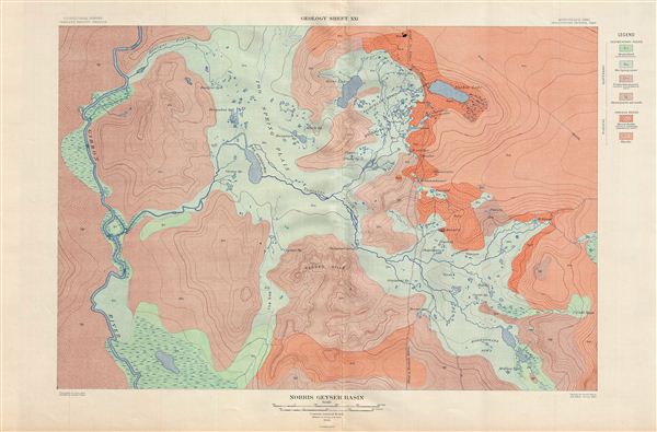 WE SELL ONLY ORIGINAL ANTIQUE MAPS - NOT REPRODUCTIONS Title: Norris Geyser Basin. Geology Sheet XXI. Description: A fine example of Arnold Hagues 1904 topographical survey map of the spectacular Norris Geyser Basin in Yellowstone National Park, Wyoming. Centered on Tantalus Creek and the Reservoir (100 Spring Plain), the map covers the basin Gibbon River to Nuphar Lake inclusive of the Porcelain Basin, Sieve Lake, the Gray Lakes, and the Ragged Hills. Identifies numerous Geysers throughout. The Norris Geyser Basin is home to the worlds largest geyser, the Steamboat Geysers, which can reach 380 feet during its rare eruptions. This particular map was part of Hagues study of the regions unique geology and the related geothermal activity. The map is color coded to indicate geological zones with a legend set in the upper right quadrant. Published by the United States Geological Survey in 1904. Size: Printed area measures 20.5 inches high by 28.5 inches wide. Condition: Very good. Blank on verso. Original Centerfold. Shipping: Shipping rates are not negotiable. Items are shipped within three business days of receiving payment. We are happy to consolidate shipping where possible. The following shipping options are available: 1. FedEx Overnight (45 USD). USA Only. Signature Required. Customs: International buyers are responsible for paying duty and taxes on delivery. DHL or FedEx will contact the buyer by telephone to arrange tax payment if it is levied. Duty varies by country and we cannot predict the amount you will be charged. Some countries are duty free, others are not. Typically, a customs duty and/or VAT tax will be assessed on all parcels to continental Europe. Sometimes duty or tax is due in China, but is seems very random. Hong Kong, Singapore, Korea, and Taiwan have never assessed duty on a map we shipped. Maps shipped to the UK should be duty free as educational materials, but from time to time duty of 5% is assessed incorrectly by the UK customs agents. Insurance: All shipments are insured privately against loss and damage. All of our shipments require a signature for insurance purposes. If you have any questions please feel free to email us through eBay. Other Services Conservation Framing: Geographicus recommends basic conservation framing services for any antique paper. We do not offer this service. |

" class="zoomMainImage swiper-slide">
1904 USGS Geologic Map of Norris Geyser Basin, Yellowstone National Park WE SELL ONLY ORIGINAL ANTIQUE MAPS - NOT REPRODUCTIONS Title: Norris Geyser Basin. Geology Sheet XXI. Description: A fine example of Arnold Hagues 1904 topographical survey map of the spectacular Norris Geyser Basin in Yellowstone National Park, Wyoming. Centered on Tantalus Creek and the Reservoir (100 Spring Plain), the map covers the basin Gibbon River to Nuphar Lake inclusive of the Porcelain Basin, Sieve Lake, the Gray Lakes, and the Ragged Hills. Identifies numerous Geysers throughout. The Norris Geyser Basin is home to the worlds largest geyser, the Steamboat Geysers, which can reach 380 feet during its rare eruptions. This particular map was part of Hagues study of the regions unique geology and the related geothermal activity. The map is color coded to indicate geological zones with a legend set in the upper right quadrant. Published by the United States Geological Survey in 1904. Size: Printed area measures 20.5 inches high by 28.5 inches wide. Condition: Very good. Blank on verso. Original Centerfold. Shipping: Shipping rates are not negotiable. Items are shipped within three business days of receiving payment. We are happy to consolidate shipping where possible. The following shipping options are available: 1. FedEx Overnight (45 USD). USA Only. Signature Required. Customs: International buyers are responsible for paying duty and taxes on delivery. DHL or FedEx will contact the buyer by telephone to arrange tax payment if it is levied. Duty varies by country and we cannot predict the amount you will be charged. Some countries are duty free, others are not. Typically, a customs duty and/or VAT tax will be assessed on all parcels to continental Europe. Sometimes duty or tax is due in China, but is seems very random. Hong Kong, Singapore, Korea, and Taiwan have never assessed duty on a map we shipped. Maps shipped to the UK should be duty free as educational materials, but from time to time duty of 5% is assessed incorrectly by the UK customs agents. Insurance: All shipments are insured privately against loss and damage. All of our shipments require a signature for insurance purposes. If you have any questions please feel free to email us through eBay. Other Services Conservation Framing: Geographicus recommends basic conservation framing services for any antique paper. We do not offer this service. |
" alt="1904 USGS carte géologique du bassin de geysers de officiel Norris, parc national de Yellowstone" width="527" height="527" />

1904 USGS carte géologique du bassin de geysers de officiel Norris, parc national de Yellowstone
1904 USGS carte géologique du bassin de geysers de officiel Norris, parc national de Yellowstone, 1904 USGS carte géologique du bassin de geysers de Norris, parc national de Yellowstone bien
€246.35
SKU: 6558252
Colour
"
1904 USGS Geologic Map of Norris Geyser Basin, Yellowstone National Park
WE SELL ONLY ORIGINAL ANTIQUE MAPS - NOT REPRODUCTIONS
Title: Norris Geyser Basin. Geology Sheet XXI.
Description: A fine example of Arnold Hagues 1904 topographical survey map of the spectacular Norris Geyser Basin in Yellowstone National Park, Wyoming. Centered on Tantalus Creek and the Reservoir (100 Spring Plain), the map covers the basin Gibbon River to Nuphar Lake inclusive of the Porcelain Basin, Sieve Lake, the Gray Lakes, and the Ragged Hills. Identifies numerous Geysers throughout. The Norris Geyser Basin is home to the worlds largest geyser, the Steamboat Geysers, which can reach 380 feet during its rare eruptions. This particular map was part of Hagues study of the regions unique geology and the related geothermal activity. The map is color coded to indicate geological zones with a legend set in the upper right quadrant. Published by the United States Geological Survey in 1904.
Size: Printed area measures 20.5 inches high by 28.5 inches wide.
Condition: Very good. Blank on verso. Original Centerfold.
Shipping: Shipping rates are not negotiable. Items are shipped within three business days of receiving payment. We are happy to consolidate shipping where possible. The following shipping options are available:1. FedEx Overnight (45 USD). USA Only. Signature Required.
2. FedEx Ground or Home Delivery (15 USD). USA Only. 1 - 10 days. If your address is a P.O. Box and cannot ship FedEx we will ship USPS Priority and, while we ship promptly, recent postal personnel cutbacks mean that delivery may take time. Signature Required.
3. FedEx International or DHL International EXPRESS (45 USD).
4. We can use your FedEx Account.
Customs: International buyers are responsible for paying duty and taxes on delivery. DHL or FedEx will contact the buyer by telephone to arrange tax payment if it is levied. Duty varies by country and we cannot predict the amount you will be charged. Some countries are duty free, others are not. Typically, a customs duty and/or VAT tax will be assessed on all parcels to continental Europe. Sometimes duty or tax is due in China, but is seems very random. Hong Kong, Singapore, Korea, and Taiwan have never assessed duty on a map we shipped. Maps shipped to the UK should be duty free as educational materials, but from time to time duty of 5% is assessed incorrectly by the UK customs agents.
Insurance: All shipments are insured privately against loss and damage. All of our shipments require a signature for insurance purposes.
If you have any questions please feel free to email us through eBay.
Other ServicesConservation Framing: Geographicus recommends basic conservation framing services for any antique paper. We do not offer this service.
Antique Map Restoration: Geographicus can repair and restore your antique map. Services include deacidification cleaning flattening and backing.
BEWARE anyone attempting to contact you, from a different eBay account, claiming to represent Geographicus Antique Maps. My eBay handle is GeographicusMaps. If you are contacted by email by someone offering you my items, please call me directly to be certain you are not dealing with a con artist." alt="1904 USGS carte géologique du bassin de geysers de officiel Norris, parc national de Yellowstone" width="52" height="52" >
Personalised:: ( x )Personalisation:EditRemove PersonalisationAvailable From:
Buy now.
Pay later.
Earn rewards
Representative APR: 29.9% (variable)
Credit subject to status. Terms apply.
Missed payments may affect your credit score
FrasersPlus
Available Products
SIMILAR ITEMS
- 1904 USGS carte géologique du bassin de geysers de Norris, parc national de Yellowstone
- chaîne hi-fi, LG, modèle CM1560 avec connexion, Bluetooth possible
- 059130755BG POMPE À INJECTION / 0445010642 / 6433571 POUR AUDI A5 COUPE 8T *
- Authentique collier Christian Dior CD logo strass SUPERBE !
- Figurine vintage Overbeck Sisters Belle Lady du Sud avec parasol rose et bleu 4,5"
- Bracelet tennis maillon unique en moissanite rond testé 4 carats plaqué or jaune 14 carats
- pantalon noir kei ninomiya (autre) blanc x noir (chèque Glen) M 2200373629183
- Woolrich WFM251.001.1100 Sneakers Sportives Homme Lacs En Cuir
- Vintage Femme Veste Kenzo Jeans Doudoune M
- Escarpins Christian Louboutin bout ouvert talons écharpe logo cuir taille 34,5 noir
Back to top